



Fast 24-Hour Turnaround
Rush delivery available when needed.
High-Accuracy Driveway Site Plans
Clear, professional drawings you can rely on.
No Site Visit Required
Revision included with every order.

Driveway Site Plan for Permit & Curb Cut Approval
Whether you need a site plan for new driveway construction, a curb cut, or a circular entrance, we provide the technical drawings your city’s public works department requires. Or planning a circular entrance, Prime Site Plan provides the technical drawings required by your city’s public works or building department. We accurately map your property’s access points, ensuring all widths, lengths, and setbacks from utilities are clearly labeled.
Infrastructure Mapping in Your Driveway Site Plan
Our remote drafting process uses high-resolution imagery and GIS infrastructure data to map your property’s access points relative to public roads and sidewalks. We ensure all radii and street-side assets are clearly labeled to meet municipal standards.
How to Get a Driveway Site Plan for Permit Approval

Our site plans are non-certified and are not intended to replace a legal survey.
The Prime Advantage
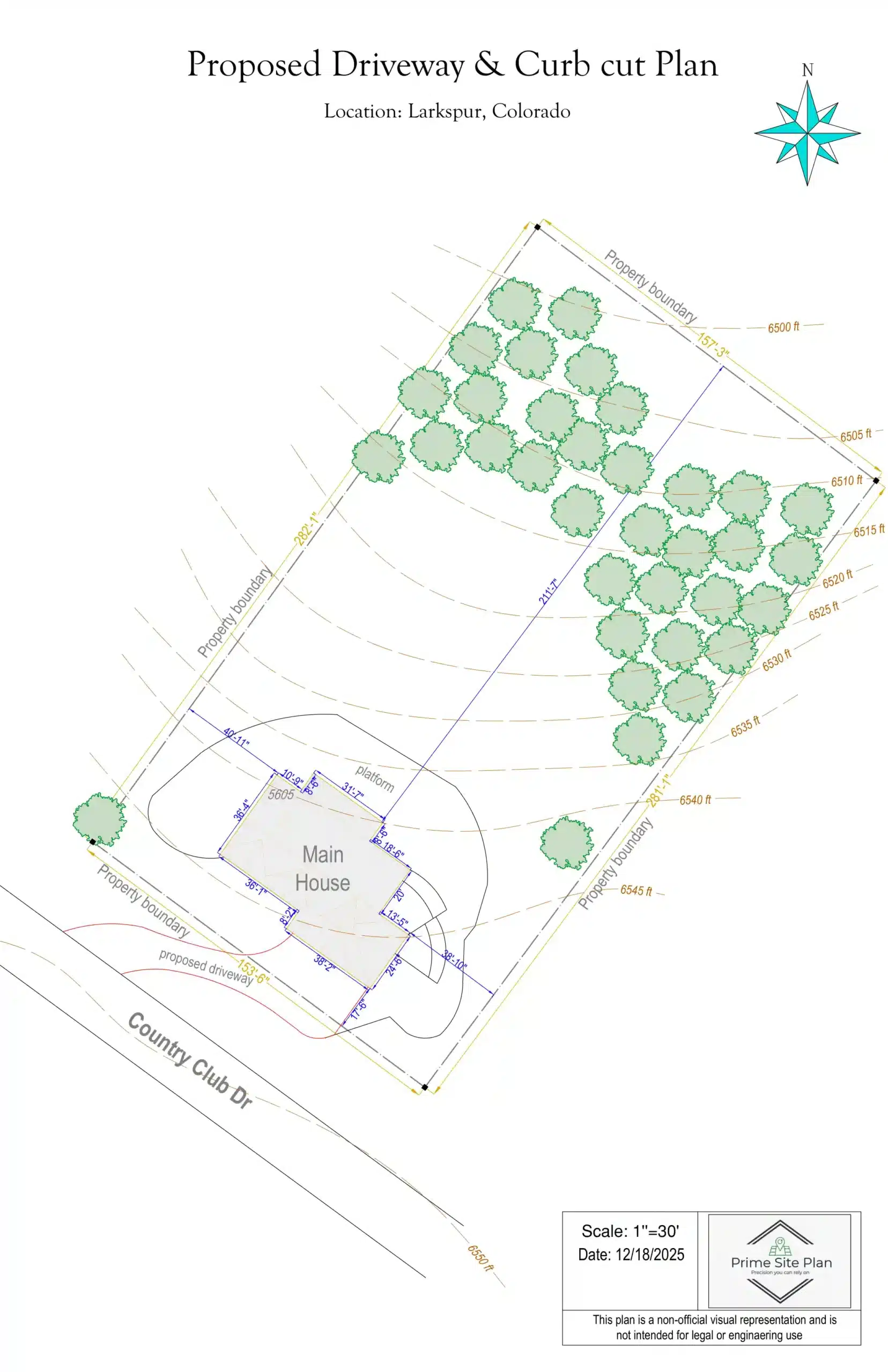
Example: Curb Cut Permit Site Plan in Larkspur, CO
A new driveway that connects to a public road is not just a building department matter — it’s an access permit, and in Douglas County it’s reviewed by public works engineers rather than residential plan checkers. Cutting into a public curb changes how water drains and how traffic enters the roadway, so the technical bar is higher than most homeowners expect.
The sample above shows precise dimensioning from both the property boundaries and the main roadway — the measurement reviewers check first. It includes turning radii, apron dimensions, sidewalk clearances, and utility setbacks, mapped against street-side infrastructure like curbs, hydrants, and buried lines.
Colorado’s terrain adds another wrinkle: on a sloped approach, the grade of the apron matters as much as its width. That’s why a driveway site plan for permit submission has to show the relationship between your access point and the road, not just the driveway itself. Every curb cut permit site plan we deliver includes unlimited revisions at no cost.
Choose your plan level below — driveway site plan delivered in 24 hours.

Base Site Plan
Efficient and accurate site plan for small residential projects and simple permit applications. Features included:
- Property boundaries
- Primary structure
- Lot dimensions
- North arrow
- Scale
- Parcel ID
- Address

Standard Site Plan
Detailed site plan including property boundaries, driveways, and building footprints — ideal for most residential permits. Features included:
- Property boundaries
- Primary structure
- Roof line
- Lot dimensions
- Driveways / parking areas
- Fence
- Landscaping elements
- North arrow
- Scale
- Measurements between major features
- Parcel ID
- Address
- Add new structures (option)

Elite Site Plan
High-detail site plan with zoning and advanced measurements for complex residential projects. Features included:
- Property boundaries
- Primary structure
- Roof line
- Lot dimensions
- Driveways / parking areas
- Walkways
- Sidewalks
- Fence
- Landscaping & terrain features
- North arrow
- Scale
- Measurements between major features
- Parcel ID
- Address
- Add new structures (option)

Commercial Site Plan
Comprehensive commercial site plan including parking, access, structures, and site improvements. Features included:
- Property boundaries
- Primary structure(s)
- Roof line(s)
- Lot dimensions
- Driveways / parking lots
- Landscaping & terrain features
- Walkways
- Fence
- Sidewalks
- North arrow
- Scale
- Measurements between major features
- Parcel ID
- Address
- Add new structures (option)
What Clients Say About Our Driveway Site Plans
Real feedback from homeowners and contractors who used our site plans for driveway and curb cut permits across the U.S.
Reviews
James Anderson
Excellent service! The utility setback data on my curb cut plan prevented a costly mistake. Very accurate and professional.
Jessica Martinez
Clear, detailed driveway plan. The infrastructure mapping was spot on and my contractor loved the precision.
David Miller
They helped me navigate the public works requirements for my driveway expansion. Very knowledgeable about local codes.
Frequently Asked Questions
Everything you need to know before ordering your driveway site plan for permit submission.
Yes, most municipalities and public works departments require a site plan showing your driveway dimensions, curb cut location, turning radii, and setbacks from utilities and sidewalks. Our plans include all required data formatted to your local standards.
We map your driveway relative to sidewalks, curbs, street-side utilities, fire hydrants, and other infrastructure — ensuring your curb cut placement meets all municipal engineering standards.
We offer unlimited revisions. If public works needs adjusted turning radii or additional utility clearance data, just let us know and we’ll update it for free.
Yes. We map all entry points, turning radii, and apron dimensions with precise measurements, regardless of the complexity of your driveway configuration.
Standard turnaround is 24 hours. Rush Delivery available within 12 hours. You’ll receive a high-resolution PDF directly in your inbox.
Not Sure Which Plan Is Right for Your Project?
Every building department has different requirements. If you’re unsure about the level of detail your permit office demands, we are here to help. Send us your project details, and we’ll recommend the best fit for a successful approval.


