
ADU Permit Site Plan
An ADU permit site plan should be the first step before floor plans, contractor scheduling, or construction decisions.
Building an Accessory Dwelling Unit (ADU) has become one of the most popular ways for homeowners across the United States to increase property value, create rental income, and make better use of their land. Whether it’s a detached backyard cottage, a converted garage, or an attached guest suite, an ADU can transform an ordinary residential lot into a far more functional property.

Before you begin
However, many homeowners make the same mistake at the very beginning of the process—they focus almost entirely on the building itself. They spend weeks choosing floor plans, comparing finishes, calculating construction costs, and speaking with contractors. Only later do they discover that the biggest obstacle isn’t building the ADU at all—it’s obtaining the permit. Unlike a simple storage shed or a residential deck, an ADU is treated as a fully functional dwelling. Because people will live inside it, municipalities review these projects under much stricter zoning and building regulations. Every setback, utility connection, drainage path, lot coverage calculation, and property boundary becomes part of the approval process.
A complete ADU permit site plan brings the proposed dwelling, property boundaries, setbacks, access, and utilities together in one review-ready drawing.
This is why many permit applications are delayed long before construction begins. In many cases, the design itself isn’t the problem—the documentation is.
A professional ADU permit site plan gives city reviewers the information they need to verify that the proposed structure complies with local zoning ordinances. Without accurate dimensions, properly identified property lines, and clear documentation of existing and proposed improvements, even an otherwise excellent project may be rejected.
At Prime Site Plan, we create permit-ready site plans specifically designed for residential permit applications across the United States. By combining verified GIS property records with professional drafting standards, we help homeowners submit clear, organized documentation that simplifies the review process.
For broader background on accessory dwelling units and local land-use policy, review the U.S. Department of Housing and Urban Development ADU case study.
In this guide
Jump directly to the section you need.
ADU Permit Site Plan: What You'll Learn
By the end of this article you’ll understand:
- why ADUs receive much closer scrutiny than most residential projects;
- the difference between zoning approval and building permits;
- how setbacks and lot coverage influence your design;
- why topography and drainage become critical for many ADU applications;
- when a Standard Site Plan is sufficient and when a more detailed Elite Site Plan is the better option;
- the most common mistakes that delay permit approval.
Whether you’re planning a compact backyard cottage or a large detached guest house, understanding these principles before construction begins can save weeks of delays and potentially thousands of dollars in redesign costs.
This ADU permit site plan guide focuses on the property information reviewers need before they can approve the proposed dwelling.
Why an ADU Permit Site Plan Receives Close Municipal Review
Many homeowners are surprised when they discover that their city reviews an ADU much more carefully than other residential improvements.
The reason is simple.
A detached workshop, patio, or storage shed is considered an accessory structure. An ADU, on the other hand, becomes a second residence on the property. That single distinction changes nearly every aspect of the review process.
Once a structure includes permanent living space—with bedrooms, bathrooms, kitchens, plumbing, and electrical systems—it affects much more than the owner’s property. Municipalities must also consider neighborhood density, emergency access, infrastructure capacity, public utilities, fire safety, environmental impacts, and long-term land use planning.
Instead of evaluating only the building itself, reviewers evaluate how the entire property functions after the ADU has been added.
Questions they typically ask include:
- Does the new building respect required setbacks?
- Will the property exceed its maximum lot coverage?
- Are emergency responders able to reach both dwellings?
- Does the additional impervious surface create drainage problems?
- Will existing utility connections support another residence?
- Does the project interfere with recorded easements?
- Does the proposed location conflict with local zoning restrictions?
These questions cannot be answered using architectural floor plans alone.
They require a professionally prepared ADU permit site plan that accurately represents the entire parcel.
How an ADU Permit Site Plan Changes Property Review
Think of your property as a complete system rather than a collection of separate structures.
Adding an ADU changes that system in multiple ways.
Your property now contains another occupied building.
More people may live on the parcel.
Additional parking requirements may apply.
New utility connections might be necessary.
Stormwater runoff often increases.
Fire separation requirements become stricter.
Even landscaping can influence certain municipal reviews if mature trees or protected vegetation are affected.
Because all of these elements interact with one another, permit reviewers need a complete visual representation of the property—not just a drawing of the proposed building.
This is exactly where a professionally drafted ADU permit site plan becomes one of the most valuable documents in the permit package.
Building Permit vs. Zoning Approval: Understanding the Difference
One of the biggest sources of confusion for homeowners is assuming that a building permit automatically confirms zoning compliance.
In reality, these are two separate reviews, often performed by different departments.
The building department focuses on how the structure will be built.
The zoning department focuses on where it will be built.
Although these reviews happen at roughly the same time, they answer completely different questions.
An ADU permit site plan supports both reviews by showing where the dwelling will be built and how it relates to the entire parcel.
Building Permit Review
Building officials evaluate whether the structure complies with construction codes and safety standards.
Typical items include:
- structural framing;
- foundation design;
- roof systems;
- plumbing;
- electrical installations;
- HVAC systems;
- insulation;
- fire protection;
- emergency exits;
- energy efficiency requirements.
This review determines whether the building itself can be safely occupied.
Zoning Review
The zoning review evaluates the property’s layout rather than the construction details.
Reviewers verify:
- property boundaries;
- setback distances;
- lot coverage;
- easements;
- access routes;
- driveway locations;
- building height restrictions;
- distance between structures;
- drainage considerations;
- land-use regulations.
A project can have perfectly engineered construction drawings and still fail zoning review because the building sits just a few feet too close to a property line.
Likewise, a structurally simple garage conversion may require significant revisions if local zoning regulations limit density or parking.
This is why accurate property documentation is every bit as important as architectural drawings.
Why an ADU Permit Site Plan Matters Before Construction
Many homeowners assume an ADU permit site plan is simply another document required by the city.
In reality, it often becomes the first document a reviewer studies.
Before examining architectural drawings, engineering calculations, or construction specifications, reviewers usually want to understand one basic question:
Does this project fit on the property?
If the answer is unclear, every other document becomes secondary.
An incomplete or inaccurate site plan forces reviewers to stop, request additional information, or reject the application until missing dimensions are provided.
By contrast, a professionally prepared plan allows reviewers to verify measurements quickly and move on to the technical aspects of the permit.
For many straightforward residential projects, our Standard Site Plan provides exactly the information municipalities typically require, including verified property boundaries, existing structures, proposed improvements, setback dimensions, and essential zoning information.
The Hidden Cost of an Inaccurate ADU Permit Site Plan
Many permit delays don’t happen because homeowners are trying to break the rules.
They happen because important information was never shown clearly.
A satellite screenshot may appear accurate but fail to identify easements.
A hand sketch may omit roof overhangs that affect setback calculations.
An online design tool may estimate property boundaries without referencing official county GIS records.
Each small omission creates another question for the reviewer.
And every unanswered question usually means another review cycle.
Instead of moving toward approval, the application returns to the homeowner for revisions.
An accurate ADU permit site plan reduces these questions by presenting verified dimensions and property conditions before submission.
Professional drafting is designed to eliminate those questions before they arise.
When property boundaries, existing improvements, proposed construction, dimensions, and zoning information are presented in a clean, organized format, reviewers spend less time searching for information and more time evaluating the project itself.
That efficiency often translates into a smoother permitting experience and fewer unexpected delays.
ADU Permit Site Plan Setbacks: Why Permits Get Rejected
If there’s one zoning requirement that causes more permit revisions than almost any other, it’s setbacks.
A setback is the minimum required distance between a structure and a property line. While the concept sounds simple, setbacks become much more complicated when applied to an ADU because municipalities aren’t just measuring the building’s footprint—they’re evaluating how the new residence fits within the overall property.
Most jurisdictions establish separate front, rear, and side-yard setbacks. Depending on local regulations, detached ADUs may benefit from reduced setback requirements, while attached ADUs often have to comply with the same standards as the primary residence.
This is why relying on general advice found online can be risky.
One city may allow a detached ADU only four feet from the rear property line, while another may require ten feet or more. Historic districts, corner lots, irregular parcels, easements, or wildfire-prone areas may introduce additional restrictions that don’t apply elsewhere.
Understanding your local rules before finalizing your design is far easier—and much less expensive—than redesigning the project after submitting a permit application.
The ADU permit site plan should measure the proposed structure from the correct building projection required by local code.
It's Not Just the Walls That Matter
One of the biggest misconceptions homeowners have is believing setbacks are measured only from the exterior walls.
In reality, municipalities often evaluate the furthest projection of the structure.
Depending on local code, that could include:
- roof overhangs,
- exterior staircases,
- entry landings,
- balconies,
- covered porches,
- mechanical equipment,
- attached canopies.
Imagine designing an ADU that appears to meet every setback requirement based on the walls alone. During plan review, the city discovers that the roof extends another 18 inches toward the property line.
Suddenly, the project no longer complies.
Instead of issuing a permit, the reviewer requests revisions.
The homeowner must redesign the roof, modify the structure, or relocate the building entirely.
Problems like these are surprisingly common because they aren’t obvious when looking at a rough sketch or satellite image.
Professional site plans illustrate these projections clearly so reviewers understand exactly where every element of the proposed structure will be located.
Fire Separation Is Closely Connected to Setbacks
Another reason setback measurements are so important is fire safety.
The closer two residential structures are to each other, the greater the risk that a fire could spread from one building to the next.
Because an ADU is intended for permanent occupancy, local building departments often evaluate the relationship between the primary residence and the new dwelling as carefully as they evaluate the distance to neighboring properties.
In some jurisdictions, reduced separation distances may require additional fire-rated wall assemblies, limitations on window openings, or other protective measures.
Accurate measurements shown on the site plan allow reviewers to determine whether additional fire protection requirements apply before construction begins.
A clear ADU permit site plan gives reviewers the separation dimensions needed to identify fire-protection requirements.
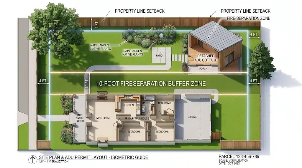
Figure 1: A visual guide illustrating typical setback measurements and fire separation considerations for a detached ADU.
ADU Permit Site Plan Lot Coverage: What Homeowners Miss
Even if your ADU meets every setback requirement, your permit can still be denied.
Why?
Because your property may exceed its maximum allowable lot coverage.
Lot coverage refers to the percentage of your parcel occupied by buildings and other impervious surfaces.
These calculations help municipalities control neighborhood density while also managing stormwater runoff and environmental impacts.
Many homeowners assume only the new ADU counts toward this limit.
Unfortunately, that’s rarely the case.
Cities often calculate the combined area of every qualifying impervious surface already present on the property.
The ADU permit site plan should document existing and proposed impervious areas so lot coverage can be checked before filing.
That may include:
- the primary residence,
- detached garages,
- sheds,
- patios,
- driveways,
- sidewalks,
- concrete pads,
- swimming pools,
- outdoor recreational areas.
If you’ve already installed a pool or large patio, adding a detached ADU may push the property beyond the maximum permitted coverage.
This is one reason homeowners planning multiple backyard improvements should evaluate the entire project rather than each structure individually.
If you’re also considering a swimming pool, our Pool Permit Site Plan Guide explains how additional hardscape and water features can affect lot coverage calculations.
Likewise, decks, patios, and outdoor entertainment spaces can significantly influence zoning compliance depending on the municipality. You can learn more in our Deck & Patio Zoning Guide.
How an ADU Permit Site Plan Saves Review Time
Imagine a homeowner with a 10,000-square-foot lot.
The property already contains:
- a 2,300-square-foot house,
- a detached garage,
- a swimming pool,
- a large patio,
- concrete walkways,
- an extended driveway.
The owner assumes there’s plenty of room for a 700-square-foot ADU.
Physically, there is.
Legally, there may not be.
Once every existing impervious surface is included in the zoning calculations, the property could already be close to its maximum allowable coverage.
Adding the ADU pushes it beyond the municipal limit.
The permit isn’t denied because the ADU is too large.
It’s denied because the property as a whole exceeds zoning regulations.
This is exactly the type of issue that can be identified before submitting an application.
A properly calculated ADU permit site plan can reveal this conflict before the homeowner pays for a design that cannot be approved.
At Prime Site Plan, we calculate how the proposed improvements affect the overall property layout, helping homeowners understand potential zoning conflicts before they become costly permit revisions.
Easements an ADU Permit Site Plan Must Show
One of the biggest surprises for first-time ADU builders is discovering that not every part of their land can actually be built on.
Although you own the property, certain portions may be reserved for utility companies, municipalities, drainage systems, or access rights.
These reserved areas are known as easements.
Unlike fences or buildings, easements are usually invisible when standing in the backyard.
You won’t see them from your patio.
They don’t appear as painted lines across the grass.
Yet they carry significant legal weight.
Constructing an ADU over a recorded easement can delay or completely prevent permit approval.
The ADU permit site plan should identify recorded easements and keep the proposed foundation outside restricted areas.
Common utility easements may protect:
- underground sewer lines,
- water mains,
- storm drainage infrastructure,
- electrical service,
- gas lines,
- telecommunications cables.
Building departments routinely compare submitted site plans against official property records.
If the proposed foundation conflicts with an easement, reviewers will require changes regardless of how attractive or expensive the design may be.
Planning Utility Connections on an ADU Permit Site Plan
Unlike a storage shed, an ADU isn’t simply placed in the backyard.
It needs to function as a residence.
That means providing water, electricity, sewer connections, and in many cases internet or gas service.
The routing of these utilities matters.
Connection paths should avoid conflicts with existing structures, mature trees, retaining walls, drainage systems, and recorded easements.
Showing these utility relationships clearly on the site plan gives reviewers a better understanding of how the project integrates with the property as a whole.
An ADU permit site plan can also show proposed utility routes and their relationship to easements, structures, and access paths.
Related Reading
If you’re planning multiple improvements, these guides may also help:
Many residential projects combine two or more of these improvements. Understanding how they interact during the permit process can help avoid unexpected zoning conflicts later.
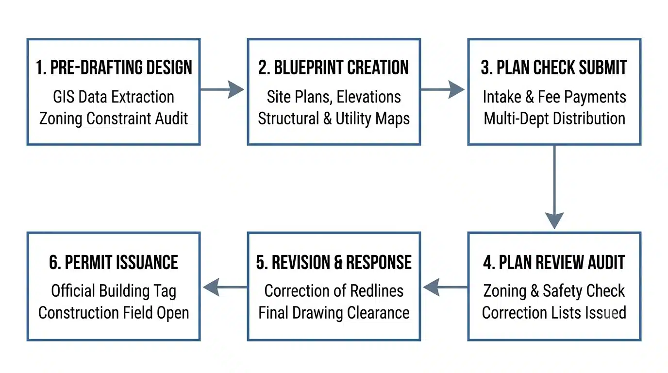
Figure 2: Typical municipal review process for an ADU permit application, from submission through final approval.
Topography and Drainage on an ADU Permit Site Plan
Many homeowners imagine the perfect ADU project as a simple process:
Choose a design → place it in the backyard → submit plans → receive approval.
On flat properties with straightforward layouts, the process may be relatively simple.
However, many residential lots across the United States are not perfectly flat. Sloped yards, uneven terrain, drainage channels, retaining structures, and elevation changes can significantly affect whether an ADU project can be approved.
This is where topography becomes an important part of the permitting process.
Topography describes the physical shape and elevation changes of the land. A professional site plan can show how the existing terrain interacts with the proposed structure, helping reviewers understand whether the project creates potential issues with grading, drainage, erosion, or foundation stability.
On sloped lots, an ADU permit site plan helps reviewers understand how the dwelling relates to existing grades and drainage patterns.
Why Sloped Properties Require Additional Planning
A small change in elevation may not seem important when standing in the backyard, but even moderate slopes can dramatically affect construction.
An ADU placed on sloped terrain may require:
- additional grading;
- excavation;
- retaining walls;
- engineered foundations;
- drainage improvements;
- modified access paths;
- erosion control measures.
Without understanding the existing land conditions, homeowners may discover construction challenges after the design has already been completed.
For example, an ADU location that appears ideal from an aerial image may actually sit on a slope where water naturally flows during heavy rain.
If the new foundation blocks that natural drainage path, water can collect near the structure, creating long-term moisture and stability problems.
This is why professional site planning considers more than just where the building fits visually.
The question is not only:
“Can the ADU physically fit here?”
The more important question is:
“Can the ADU safely function here while meeting local regulations?”
Drainage Problems Are Often Invisible Before Construction
One of the most overlooked parts of residential development is stormwater movement.
Every property has a natural drainage pattern.
Rainwater follows the existing slope of the land, moving toward lower elevations, drainage systems, streets, or designated collection areas.
When homeowners add new structures, concrete surfaces, or grading changes, they can unintentionally redirect that water.
A new ADU foundation, walkway, patio, or driveway extension can change how water moves across the property.
Potential problems include:
- water collecting near foundations;
- erosion of surrounding soil;
- runoff entering neighboring properties;
- damage to landscaping;
- conflicts with municipal drainage requirements.
For this reason, some municipalities require additional documentation when a proposed project changes existing grading conditions.
A detailed site plan helps communicate how the proposed ADU fits into the existing landscape and whether additional drainage considerations may be necessary.
When an Elite Site Plan Becomes the Better Choice
Not every ADU project requires the same level of detail.
A simple detached backyard unit on a flat residential lot may only require standard property information, existing structures, setbacks, and proposed improvements.
However, more complex properties often require additional analysis.
Examples include:
- steep hillside lots;
- properties with significant elevation changes;
- ADUs near retaining walls;
- projects involving extensive grading;
- properties with drainage challenges;
- large backyard developments combining multiple structures.
For these situations, our Elite Site Plan provides a higher level of detail designed for more demanding residential projects. It is especially useful when topography, slopes, additional improvements, or complex zoning conditions become part of the permit review process.
ADU Permit Site Plan vs. DIY Drawings: Why Accuracy Matters
With modern technology, many homeowners attempt to create their own site plans.
Aerial imagery is easily available.
Online mapping tools are convenient.
AI design tools can create impressive visual concepts.
However, there is a major difference between a visually attractive drawing and a document suitable for municipal review.
A permit reviewer does not only need to see what the property looks like.
They need measurable, reliable information.
Unlike a concept image, an ADU permit site plan must communicate measurable property information suitable for municipal review.
The Problem With Satellite Screenshots
Satellite images are useful for understanding the general appearance of a property.
They are not designed to replace professional drafting.
Aerial imagery can contain several limitations:
Property Boundaries
A satellite image does not always show official parcel boundaries accurately.
The visible fence line may not match the legal property line.
A neighbor’s landscaping may extend beyond their actual boundary.
Old fences may have been installed incorrectly decades ago.
Structural Accuracy
Satellite images capture buildings from above, but they don’t always represent exact ground-level dimensions.
Roof edges, overhangs, trees, and shadows can create misleading impressions.
A structure may appear larger or smaller than it actually is.
Missing Legal Information
Satellite images do not show:
- recorded easements;
- zoning restrictions;
- utility corridors;
- drainage requirements;
- official land records.
These details are often exactly what determines whether a permit is approved.
How GIS Data Improves an ADU Permit Site Plan
Professional site planning combines multiple sources of information.
Geographic Information System (GIS) data allows professionals to analyze property information using official land records, parcel boundaries, aerial imagery, and other spatial information.
Instead of relying on one image, GIS-based planning creates a more complete picture of the property.
This is especially valuable for ADU projects because the reviewer needs confidence that the proposed improvements are correctly positioned within the parcel.
For homeowners interested in understanding how professional property verification works, our guide on GIS Land Records & Professional Site Verification explains why accurate land data is one of the foundations of successful permit preparation.
GIS records strengthen an ADU permit site plan by providing parcel data that can be compared with plats, aerial imagery, and existing improvements.
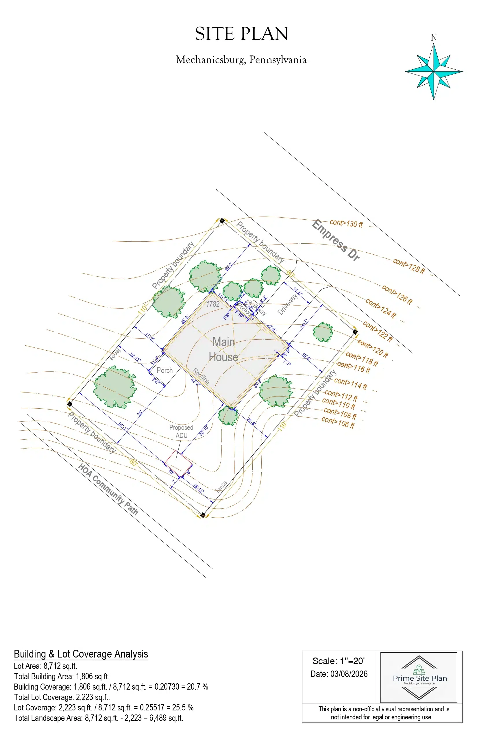
Figure 3: Example of a completed residential site plan showing property boundaries, existing structures, setback information, and proposed ADU placement.
Common ADU Permit Site Plan Mistakes That Cause Delays
Even well-planned ADU projects can experience delays because of small documentation mistakes.
Below are some of the most common problems homeowners encounter.
Most avoidable delays begin when the ADU permit site plan omits a dimension, structure, easement, or other review-critical detail.
1. Designing the ADU Before Checking Zoning Requirements
Many homeowners start with the building design first.
They choose the size, layout, and location before confirming whether the property can legally support that structure.
A better approach is to understand zoning limitations first.
Setbacks, lot coverage, easements, and access requirements should influence the design from the beginning.
2. Ignoring Existing Improvements
Homeowners often focus only on the new ADU.
However, municipalities usually evaluate the entire property.
Existing features such as:
- pools;
- decks;
- patios;
- driveways;
- sheds;
- garages;
can all affect zoning calculations.
A project that works on an empty lot may not work on a developed residential property.
3. Using Inaccurate Property Information
Submitting a plan based only on an old sketch or online image can create problems during review.
Incorrect dimensions, missing structures, or inaccurate boundaries may require revisions after submission.
Starting with verified information reduces unnecessary back-and-forth.
4. Forgetting About Future Improvements
Some homeowners build an ADU first and later discover that the new structure limits future plans.
For example:
- a future pool may no longer fit within lot coverage limits;
- a planned deck may conflict with setbacks;
- landscaping improvements may interfere with drainage requirements.
Thinking about the entire property vision helps create a better long-term plan.
Do I need a site plan for an ADU permit?
In most jurisdictions, yes. Because an ADU changes the use and density of a residential property, municipalities typically require documentation showing the proposed structure’s location, dimensions, and relationship to existing property features.
Can I use a Google Earth image instead of a professional site plan?
Aerial images can be helpful for reference, but they usually do not provide the accuracy and legal information required for permit review.
Professional site plans include measured information, property boundaries, zoning considerations, and project-specific details.
How long does an ADU permit approval take?
The timeline depends on the municipality, project complexity, and whether revisions are required.
Applications with incomplete or inaccurate documentation often experience longer delays because reviewers must request additional information.
Is a Standard Site Plan enough for every ADU project?
Not every project requires advanced documentation.
A Standard Site Plan is often appropriate for straightforward residential projects on relatively simple properties.
However, properties with slopes, complex terrain, multiple improvements, or additional zoning challenges may benefit from an Elite Site Plan.
What Information Should an ADU Permit Site Plan Include?
Requirements vary by location, but many permit applications require:
A complete ADU permit site plan commonly includes the following information:
- property boundaries;
- existing structures;
- proposed ADU location;
- setbacks;
- dimensions;
- access paths;
- utility information;
- relevant zoning details.
Final Thoughts: A Successful ADU Permit Site Plan Starts With Accurate Planning
An ADU can be one of the most valuable improvements you make to your property.
It can create additional living space, increase flexibility, and add long-term value.
But successful ADU development begins long before construction.
The foundation of the project is not only the building design—it is understanding how that building interacts with the property around it.
Setbacks, lot coverage, easements, drainage, topography, and accurate property information all influence whether a permit application moves forward smoothly.
A professional site plan transforms complicated property information into a clear document that helps homeowners, contractors, and municipal reviewers understand the project.
At Prime Site Plan, we help homeowners prepare accurate, permit-ready site plans using professional drafting methods and verified property information.
Whether you are planning a simple backyard cottage or a more complex ADU project involving slopes, drainage, or multiple improvements, choosing the right level of documentation can make the permitting process significantly easier.
A well-prepared ADU permit site plan gives the project a stronger foundation by identifying property constraints before construction costs begin.
Choose the right site plan for your project
Both options are professionally drafted to support a clearer municipal review for adus & development projects.
Standard Site Plan
Ideal for straightforward ADU layouts, garage conversions, and level properties that need clear boundaries and setbacks.
Elite Site Plan
Recommended for sloped lots, drainage concerns, grading, several proposed improvements, or complex ADU site conditions.