
GIS Property Verification
GIS property verification gives homeowners a reliable starting point before they rely on Google Earth or other online maps.
When homeowners begin planning a construction project, one of the first things they usually do is open Google Earth or an online property map. Within seconds, they can see their entire lot from above, identify where a new structure might fit, and even estimate distances using built-in measuring tools.

Before you begin
GIS property verification separates visual references from the measurable records needed for permit review.
At first glance, it seems like everything needed for a permit application is already available. So why pay for a professionally prepared site plan? The answer lies in the difference between visual information and permit-ready documentation.
A satellite image is designed to help people explore locations. A site plan is designed to communicate accurate, measurable information that local building departments use to evaluate zoning compliance, property layout, and proposed construction.
Although both may show the same property, they serve completely different purposes.
This distinction becomes important the moment a permit application reaches a municipal reviewer.
Building departments don’t simply need to know where your project is located they need to verify whether it complies with local regulations.
That means understanding property boundaries, setbacks, existing improvements, lot coverage, utility easements, drainage considerations, and dozens of other details that aren’t visible in a simple aerial photograph.
This is why homeowners are often surprised when a drawing that looks perfectly clear to them generates requests for revisions from the city.
The issue usually isn’t the project itself.
It’s the documentation supporting it.
At Prime Site Plan, we prepare permit-ready site plans using verified property information, GIS data, and professional drafting standards to help homeowners present clear, organized documentation for residential permit applications throughout the United States.
In this guide
Jump directly to the section you need.
What GIS Property Verification Covers
This guide explains:
- why aerial imagery should never be the only source for a permit application;
- how GIS data differs from ordinary online maps;
- why municipalities require professionally prepared site plans;
- common property data mistakes that delay permit approval;
- how lot coverage calculations rely on accurate mapping;
- why scale, orientation, and property boundaries matter;
- when a Standard Site Plan is appropriate and when an Elite Site Plan provides additional value.
Whether you’re planning a swimming pool, deck, garage, shed, ADU, or home addition, understanding how municipalities evaluate property information can help you avoid unnecessary revisions and costly delays.
GIS Property Verification: Why a Map and Site Plan Are Different
GIS property verification shows why an online map and a professional site plan are not interchangeable.
One of the biggest misconceptions among homeowners is believing that a satellite image is simply another version of a site plan.
Although they may appear similar at first glance, they are created for entirely different purposes.
Aerial imagery is intended to help people locate places and understand general property layouts.
A professional site plan is a technical document prepared specifically for planning, zoning, and permitting purposes.
Municipal reviewers rely on it to verify whether a proposed project complies with local regulations.
That means accuracy is far more important than appearance.
A drawing that looks clean but contains incorrect measurements can create more problems than a rough sketch that clearly identifies missing information.
Professional site plans are designed to answer questions such as:
- Where are the legal property boundaries?
- How far is the proposed structure from each property line?
- What improvements already exist on the property?
- Will the project exceed allowable lot coverage?
- Are recorded easements affected?
- Does the project interfere with required access or drainage?
These questions cannot be answered reliably using a screenshot alone.
Why GIS Property Verification Helps Municipal Reviewers
GIS property verification gives municipal reviewers a clearer and faster way to evaluate a proposed project.
Imagine two homeowners applying for permits to build identical detached garages.
The first homeowner submits a screenshot from an online mapping service.
The garage location is outlined with a red rectangle.
Several handwritten dimensions are added.
From the homeowner’s perspective, everything seems obvious.
The second homeowner submits a professionally drafted site plan.
Property boundaries are clearly identified.
Existing improvements are accurately labeled.
Setback distances are shown.
Dimensions follow a consistent scale.
The proposed garage is positioned in relation to every important feature on the property.
Which application is easier to review?
For municipal staff responsible for evaluating dozens of permit applications every week, the answer is obvious.
Professional documentation reduces uncertainty.
Instead of requesting clarification, reviewers can immediately begin evaluating compliance with local regulations.
That efficiency benefits both the municipality and the homeowner.
Why Accuracy Matters More Than Appearance
Modern software can create attractive drawings in just a few minutes.
Unfortunately, attractive doesn’t always mean accurate.
A perfectly straight property line on a screenshot may not match the legal parcel boundary.
A fence may have been installed several feet inside the actual property line years ago.
A detached shed may have been demolished after the latest aerial image was captured.
The reviewer has no way to know unless the documentation reflects verified property information.
Professional drafting isn’t about making plans look more impressive.
It’s about presenting information that municipalities can trust.
GIS Property Verification and Hidden Satellite Image Problems
GIS property verification helps identify limitations hidden behind apparently precise satellite imagery.
Satellite images create an impression of precision.
You can zoom in to individual trees.
You can measure approximate distances.
You can even identify rooflines and driveways.
Yet every aerial photograph has limitations.
Understanding those limitations explains why municipalities almost never rely on satellite imagery alone when reviewing permit applications.
Images Don't Always Represent Current Conditions
One of the simplest problems involves time.
The aerial image you see today may have been captured months or even years ago.
Since then, a property owner may have:
- expanded a driveway;
- removed a detached shed;
- installed a patio;
- added a retaining wall;
- built a swimming pool;
- modified landscaping.
Even relatively small changes can affect zoning calculations.
If your permit application is based entirely on outdated imagery, reviewers may discover discrepancies during the review process or during a site inspection.
That often results in requests for revised documentation.
Camera Angles Can Create Distortion
Another issue many homeowners never consider is perspective.
Aerial photographs are not perfect overhead blueprints.
They are photographs captured using cameras positioned hundreds or even thousands of feet above the ground.
Depending on terrain, camera angle, and surrounding structures, buildings may appear slightly shifted relative to the ground below.
This effect is especially noticeable near taller structures.
Roof edges may appear to extend beyond the actual foundation.
Tree canopies may obscure important site features.
Shadows may hide walkways or retaining walls.
Professional drafting accounts for these limitations by combining aerial imagery with verified parcel information rather than tracing photographs directly.
Small Errors Become Big Problems
Imagine your municipality requires a ten-foot side setback for a proposed detached garage.
A homeowner estimates the distance from an aerial image and believes the project complies.
In reality, the property boundary shown on the screenshot differs slightly from the legal parcel line.
The actual setback becomes eight feet instead of ten.
The garage itself hasn’t changed.
The documentation was simply inaccurate.
Situations like these explain why municipalities emphasize reliable measurements rather than visual estimates.
Every Future Project Depends on Accurate Property Information
One advantage of using a professionally prepared site plan is that it often supports future improvements as well.
Many homeowners begin with one project and later decide to expand their outdoor space.
Perhaps today’s project is a detached garage.
Next year it may be:
- a swimming pool;
- a deck or patio;
- a backyard storage shed;
- an accessory dwelling unit.
Because all of these improvements affect the same property, beginning with accurate documentation helps future planning become much easier.
If your next project involves a swimming pool, our Pool Permit Site Plan Guide explains how setbacks, drainage, and lot coverage influence permit approval.
If you’re planning an outdoor entertainment area, our Deck & Patio Zoning Guide explores how decks, patios, pergolas, and other hardscape improvements interact with municipal zoning requirements.
Why Starting With Professional Documentation Saves Time
GIS property verification reduces permit delays by organizing boundaries, dimensions, and existing conditions before submission.
Permit delays rarely happen because homeowners intentionally ignore regulations.
More often, they happen because reviewers need additional information before making a decision.
Missing dimensions.
Unknown property boundaries.
Incomplete improvement locations.
Unclear setbacks.
Each unanswered question creates another review cycle.
For many straightforward residential projects, our Standard Site Plan provides the information municipalities commonly request, including verified property boundaries, existing structures, proposed improvements, setback dimensions, and clear zoning documentation.
GIS Property Verification: The Foundation of Reliable Property Data
GIS property verification combines spatial records and mapped data so a property can be reviewed as a complete system.
Most homeowners have heard the term GIS, but relatively few understand how important it has become in modern property planning.
GIS stands for Geographic Information System, a technology used to organize, analyze, and display location-based information from multiple sources. Instead of relying on a single aerial photograph, GIS combines numerous layers of verified data into one comprehensive property record.
These layers may include:
- parcel boundaries;
- aerial imagery;
- topographic information;
- utility infrastructure;
- flood zones;
- zoning districts;
- road networks;
- easements;
- address information;
- environmental overlays.
Rather than looking at a single picture of your property, GIS allows planners to understand how that property exists within a much larger regulatory and geographic system.
For permit applications, that additional context often makes a significant difference.
Why GIS Is More Reliable Than a Simple Screenshot
GIS property verification becomes more reliable when several data layers are compared instead of relying on one image.
Imagine looking at your property through a standard aerial photograph.
You can identify your house.
Your driveway.
Perhaps your backyard shed.
That image provides useful visual information but only one layer of it.
Now imagine turning additional information on and off like transparent sheets stacked on top of each other.
One layer shows legal parcel boundaries.
Another displays flood hazard zones.
Another identifies utility easements.
Another highlights zoning districts.
Another reveals topographic contours.
Suddenly the property becomes much easier to understand not just visually, but legally and technically.
That is one of the greatest advantages of GIS-based property research.
Professional site plans don’t rely on appearance alone.
They are built using information that helps verify how a property is actually documented by public agencies.
Where GIS Information Comes From
GIS property verification draws from multiple public agencies rather than a single national database.
Public geospatial resources such as the U.S. Census Bureau TIGER data products provide boundary, road, address, and related spatial data for GIS workflows.
Many homeowners assume there is one massive national property database.
In reality, GIS information usually comes from several trusted sources.
Depending on the location, data may be provided by:
- county GIS departments;
- municipal planning agencies;
- assessor offices;
- state mapping programs;
- transportation departments;
- utility providers;
- environmental agencies.
Each organization contributes information related to its area of responsibility.
Professional drafting combines these sources into one organized site plan that is much easier for municipal reviewers to interpret.
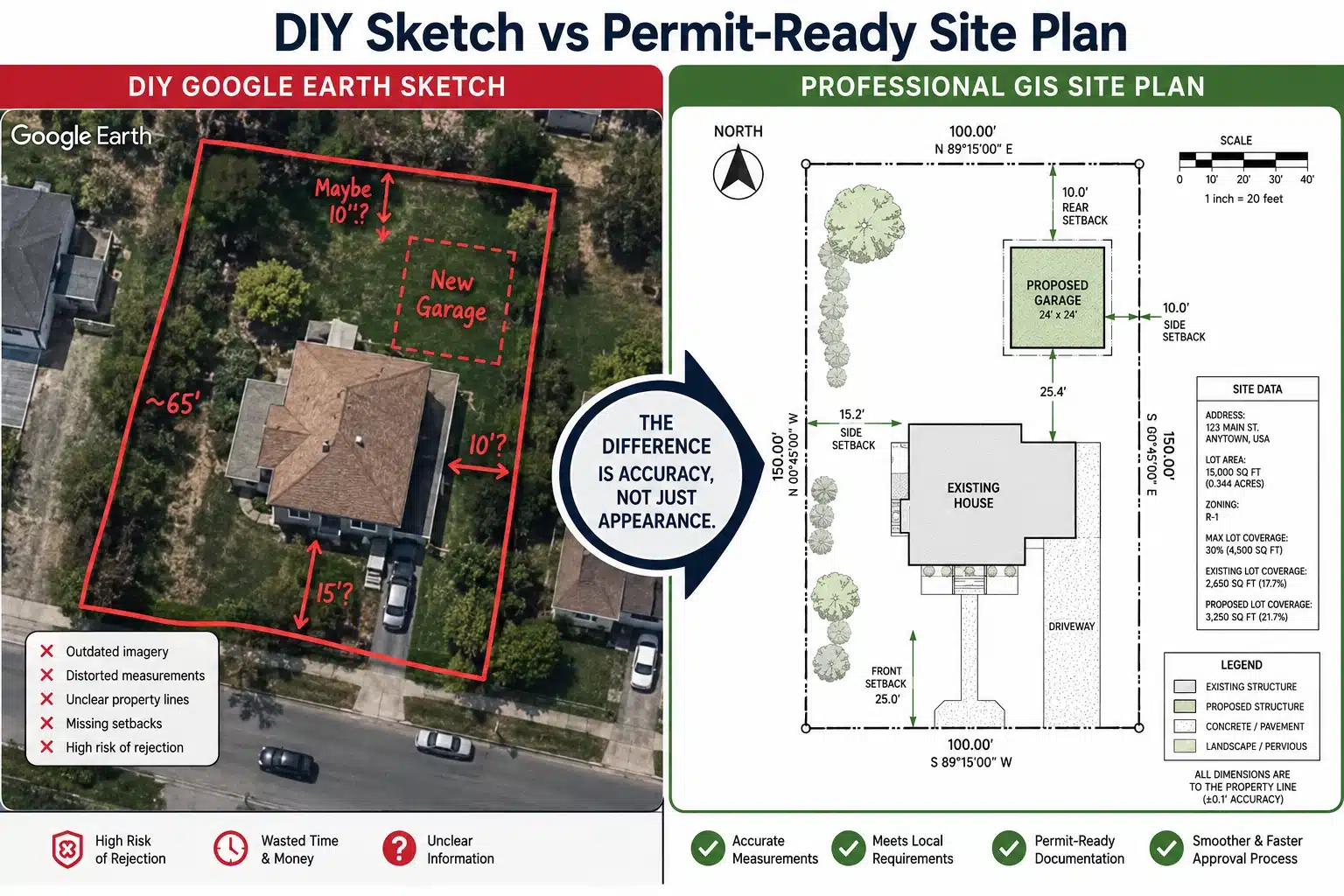
Figure 1: Comparison between a basic Google Earth property screenshot and a professionally prepared GIS-based site plan used for residential permit applications.
GIS Property Verification and Legal Property Boundaries
GIS property verification is especially important when visible fences or landscaping do not match legal parcel records.
One of the most overlooked aspects of residential planning is the property boundary itself.
Many homeowners naturally assume that visible features define ownership.
A fence must mark the property line.
A hedge probably follows the boundary.
The edge of the driveway looks correct.
Unfortunately, none of these assumptions are necessarily true.
Property ownership is defined by legal parcel records not by visible objects.
A fence may have been installed several feet inside the property decades ago.
Neighbors may have agreed to landscaping arrangements that don’t match official parcel boundaries.
Previous owners may have built improvements without considering exact property dimensions.
These situations are surprisingly common.
That’s why municipalities evaluate permit applications using legal parcel information rather than visible landmarks.
Small Boundary Errors Create Big Permit Problems
Imagine planning a detached garage.
According to measurements taken from an online image, everything appears compliant.
The garage sits exactly ten feet from the side fence.
Later, official parcel information reveals the legal property line is actually three feet farther inside.
Instead of a ten-foot setback, the structure now has only seven feet.
Nothing about the garage changed.
The misunderstanding came entirely from relying on visible features instead of verified property information.
This is one of the most common reasons municipalities request revised documentation before approving residential permits.
GIS Property Verification for Easements and Buildable Areas
GIS property verification helps reveal easements that may not be visible from the surface.
Another topic that surprises many homeowners is the concept of easements.
Owning property doesn’t necessarily mean every square foot can be developed.
An easement gives another party limited rights to use part of your property for a specific purpose.
These rights commonly involve:
- underground water lines;
- sanitary sewer systems;
- storm drainage infrastructure;
- electrical utilities;
- gas pipelines;
- telecommunications equipment;
- shared access routes.
Most easements remain completely invisible from the surface.
A beautiful open section of lawn may appear to be the perfect place for a detached garage or swimming pool.
Official records may tell a very different story.
Building within an easement can lead to permit complications, relocation requirements, or future maintenance conflicts.
Understanding these restrictions before designing the project is considerably easier than redesigning construction plans afterward.
GIS Property Verification for Accurate Lot Coverage
GIS property verification supports accurate lot coverage calculations by documenting all relevant improvements.
One of the most important calculations during residential permit review involves lot coverage.
Municipalities use these calculations to evaluate how much of a property has been developed with buildings and other impervious surfaces.
Accurate lot coverage depends entirely on accurate mapping.
If existing improvements are missing, the calculation becomes unreliable.
If dimensions are estimated incorrectly, zoning compliance may also become inaccurate.
Typical improvements included in lot coverage calculations often include:
- the primary residence;
- detached garages;
- sheds;
- patios;
- driveways;
- walkways;
- swimming pools;
- sport courts;
- outdoor kitchens.
Every municipality defines these calculations slightly differently, but accurate property information remains the starting point in every case.
If your project involves a new swimming pool or outdoor living area, our Pool Permit Site Plan Guide explains how lot coverage influences permit approval.
Likewise, our Deck & Patio Zoning Guide explores how patios, pergolas, and outdoor structures contribute to zoning calculations.
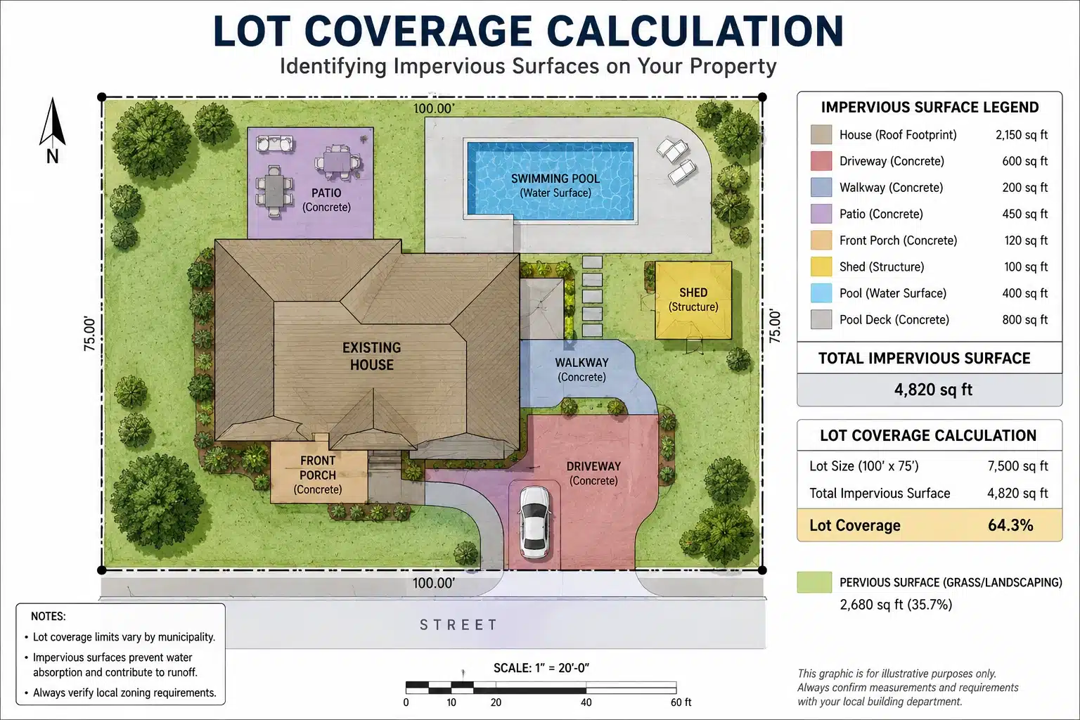
Figure 2: Example of a residential property with buildings, driveways, patios, walkways, and other impervious surfaces highlighted for lot coverage analysis.
GIS Property Verification for Topography and Sloped Sites
GIS property verification also helps explain elevation changes, drainage paths, and sloped-site constraints.
Not every property is perfectly flat.
Even gentle slopes can influence drainage, grading requirements, retaining wall design, and foundation planning.
Topographic information becomes increasingly valuable when projects involve:
- accessory dwelling units;
- detached garages;
- retaining walls;
- large patios;
- swimming pools;
- significant excavation.
Contour information helps planners understand how water naturally moves across the site and whether additional grading may become necessary.
For more complex properties involving elevation changes, municipalities often require more detailed documentation during permit review.
If your project involves sloped terrain, retaining walls, or significant grading work, our Retaining Walls & Steep Slopes Guide explains why topographic information plays such an important role during planning.
Professional Documentation Helps More Than One Project
One of the biggest advantages of having a professionally prepared site plan is that its value often extends well beyond the current permit application.
Today’s project may involve a detached garage.
Next year, the homeowner may decide to add:
- a swimming pool;
- a deck;
- a shed;
- an ADU;
- additional landscaping.
Because the property’s existing conditions have already been organized into a professional drawing, planning future improvements becomes considerably easier.
Instead of starting from scratch each time, homeowners have a reliable foundation that supports long-term property development.
For many standard residential projects, our Standard Site Plan provides the level of documentation municipalities commonly expect during permit review.
Choosing the Right Site Plan for Your Project
By the time homeowners reach the permit application stage, one question comes up more often than almost any other:
“What kind of site plan do I actually need?”
The answer depends less on the size of the project and more on the complexity of the property.
A simple detached garage on a flat suburban lot requires different documentation than a swimming pool built on a sloped property with retaining walls.
Likewise, adding a backyard shed usually involves fewer planning considerations than constructing an accessory dwelling unit (ADU).
Understanding those differences before ordering a site plan helps ensure you receive the level of documentation appropriate for your project.
When a Standard Site Plan Is the Right Choice
For many residential permit applications, a professionally prepared Standard Site Plan provides everything municipalities commonly require.
Typical projects include:
- detached garages;
- backyard sheds;
- decks;
- patios;
- swimming pools;
- fences;
- driveway expansions;
- small residential additions.
A Standard Site Plan generally illustrates:
- verified property boundaries;
- existing structures;
- proposed improvements;
- setback dimensions;
- driveways;
- walkways;
- basic zoning information;
- north arrow and drawing scale.
Because most residential permits involve relatively straightforward site conditions, this level of documentation is often sufficient for municipal review.
For homeowners planning these types of improvements, our Standard Site Plan offers a practical solution designed specifically for residential permit applications.
When an Elite Site Plan Makes Sense
Some properties involve challenges that require additional documentation beyond a standard layout.
These projects may include:
- significant grading;
- steep terrain;
- retaining walls;
- contour mapping;
- mature tree documentation;
- drainage analysis;
- larger residential developments;
- multiple proposed improvements.
In these situations, municipal reviewers frequently need more information to understand how construction will interact with the site’s existing topography.
Additional detail helps communicate the project more clearly while reducing uncertainty during review.
Our Elite Site Plan was developed specifically for these more complex residential projects.
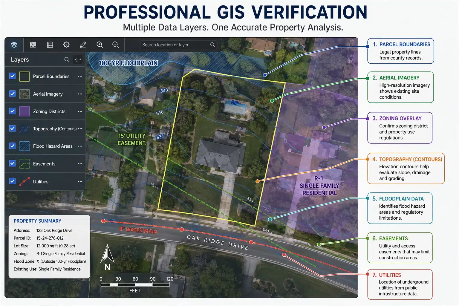
Figure 3: Illustration showing multiple GIS data layers—including parcel boundaries, aerial imagery, zoning overlays, utility easements, flood zones, and topographic contours—combined into a comprehensive property analysis.
Common GIS Property Verification Mistakes
GIS property verification prevents many avoidable mapping mistakes before a permit application reaches the city.
Accurate documentation doesn’t happen by accident.
Over the years, municipal reviewers have seen many of the same mistakes repeated in permit applications.
Fortunately, most of them are entirely avoidable.
Assuming Visible Features Define Property Lines
One of the most common misconceptions is believing that fences, hedges, or landscaping accurately represent legal property boundaries.
In reality, visible improvements are not legal survey monuments.
Planning construction around assumptions rather than verified parcel information can easily create setback conflicts.
Measuring From Buildings Instead of Property Boundaries
Homeowners often estimate distances using existing structures as reference points.
Unfortunately, zoning regulations almost always measure setbacks from legal property lines not from houses, fences, or neighboring buildings.
Using the wrong reference point can significantly affect permit compliance.
Forgetting Existing Improvements
Every permanent improvement contributes to how municipalities evaluate a property.
Driveways.
Patios.
Walkways.
Pools.
Detached garages.
Outdoor kitchens.
Storage buildings.
Leaving any of these off a site plan may result in incomplete lot coverage calculations or additional review comments.
Relying Entirely on Online Maps
Online mapping services are excellent planning tools.
They are not official permit documents.
Satellite imagery should always be considered a starting point—not the final source of property information.
Professional drafting combines aerial imagery with verified GIS data and public records to create documentation appropriate for permit review.
Can I use a Google Earth image instead of a site plan?
In some jurisdictions, a simple aerial image may be accepted for very small projects.
However, many municipalities require a professionally prepared site plan that clearly identifies property boundaries, existing improvements, proposed construction, and other zoning information.
Always verify local permit requirements before submitting an application.
What is GIS?
GIS stands for Geographic Information System.
It combines multiple sources of geographic information such as parcel boundaries, aerial imagery, zoning districts, utility easements, and topographic data into a single mapping system used by planners, engineers, surveyors, and government agencies.
Is GIS data more accurate than Google Earth?
GIS and Google Earth serve different purposes.
Google Earth provides high-quality aerial imagery for visualization.
GIS combines aerial imagery with verified public records and additional geographic datasets that support planning, analysis, and permitting.
Does every permit application require GIS information?
Not necessarily.
Homeowners rarely submit raw GIS data directly.
Instead, GIS information is often used behind the scenes during preparation of a professional site plan.
The finished drawing presents that information in a format suitable for municipal review.
Can one site plan be used for future projects?
Often, yes.
Many homeowners begin with one improvement and later expand their property.
Having professionally prepared documentation can simplify planning for future additions such as pools, patios, sheds, garages, or ADUs.
Continue Planning Your Property
If you’re researching permit requirements for a specific type of residential project, these guides provide more detailed information:
Together, these resources cover many of the planning and documentation topics homeowners encounter before submitting residential permit applications.
Final Thoughts on GIS Property Verification
Property planning begins long before construction starts.
Whether you’re building a garage, installing a swimming pool, adding a deck, constructing an ADU, or simply preparing for future improvements, the quality of your documentation has a direct impact on the permitting process.
While online maps and aerial imagery provide a useful starting point, they were never designed to replace professional site plans.
Permit reviewers need more than a picture.
They need organized, accurate, and verifiable information that clearly explains how a proposed project fits within the property and complies with local regulations.
That’s where GIS-based property research and professional drafting make a meaningful difference.
Rather than relying on assumptions, homeowners can move forward with greater confidence knowing their permit documentation is based on reliable property information.
At Prime Site Plan, we prepare permit-ready residential site plans for homeowners, contractors, designers, and property owners across the United States. Every plan is created using verified property information and professional drafting standards to help support a smoother municipal review process.
Whether you’re planning your first backyard project or managing several improvements over time, choosing the appropriate documentation at the beginning often saves both time and unnecessary revisions later.
Completed Permit-Ready Site Plan Example
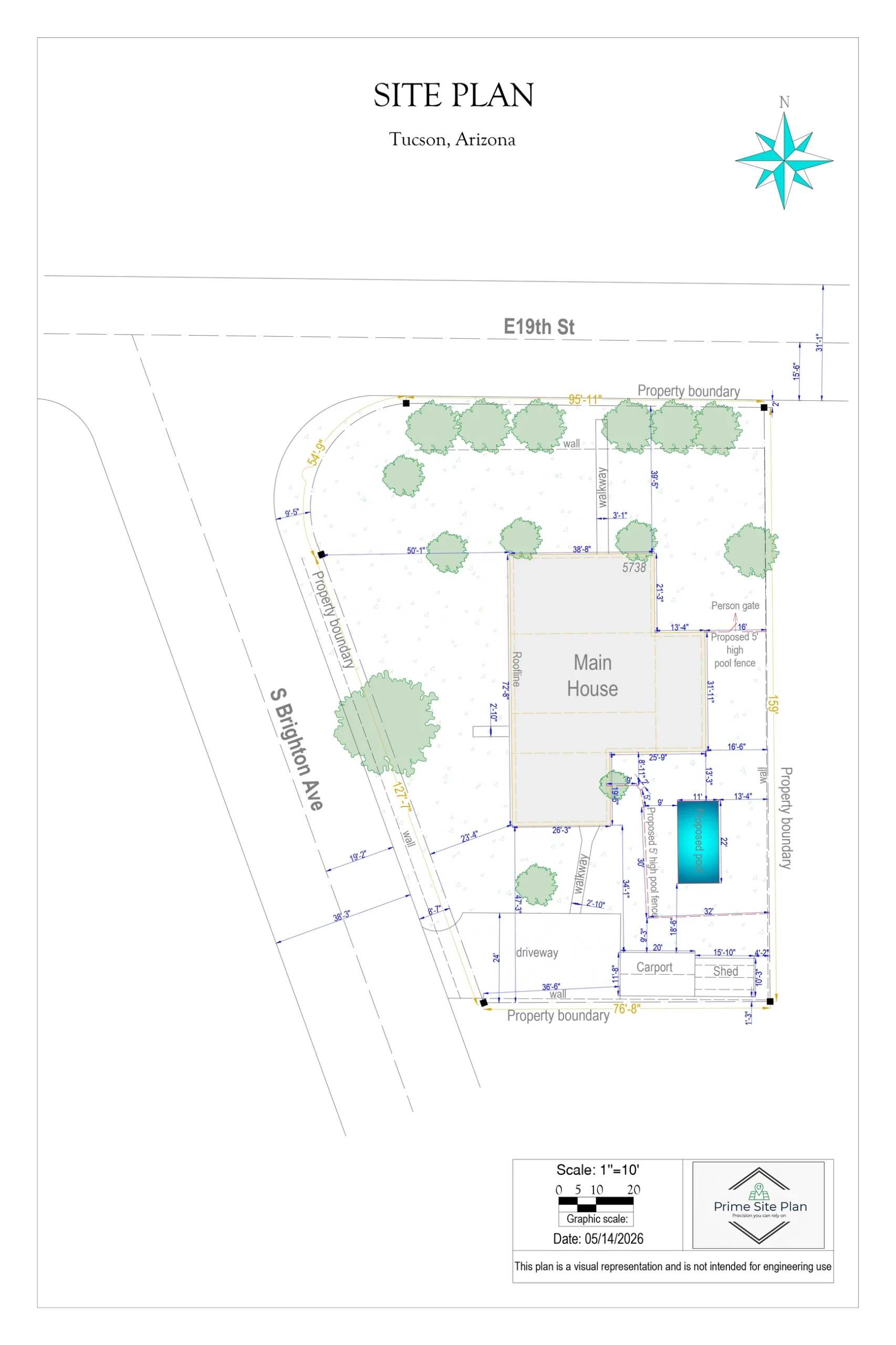
Figure 4: Example of a completed permit-ready residential site plan prepared using verified property information, clearly illustrating property boundaries, existing structures, proposed improvements, dimensions, and other documentation commonly requested during municipal permit review.
Choose the right site plan for your project
Both options are professionally drafted to support a clearer municipal review for gis & property records projects.
Standard Site Plan
Ideal for most residential permits that need verified boundaries, existing improvements, setbacks, and a clear proposed layout.
Elite Site Plan
Recommended when topography, grading, retaining walls, drainage, or several GIS data layers must be communicated clearly.