
Retaining Wall Site Plan
Retaining wall site plan preparation should be the first step before excavation, grading, material selection, or contractor scheduling. Building on a hillside offers some of the most breathtaking views and unique architectural opportunities a homeowner can experience. Whether you are looking to carve out a flat terrace for a new swimming pool, secure a shifting hillside, or maximize your usable backyard space, sloped properties possess an undeniable aesthetic appeal.
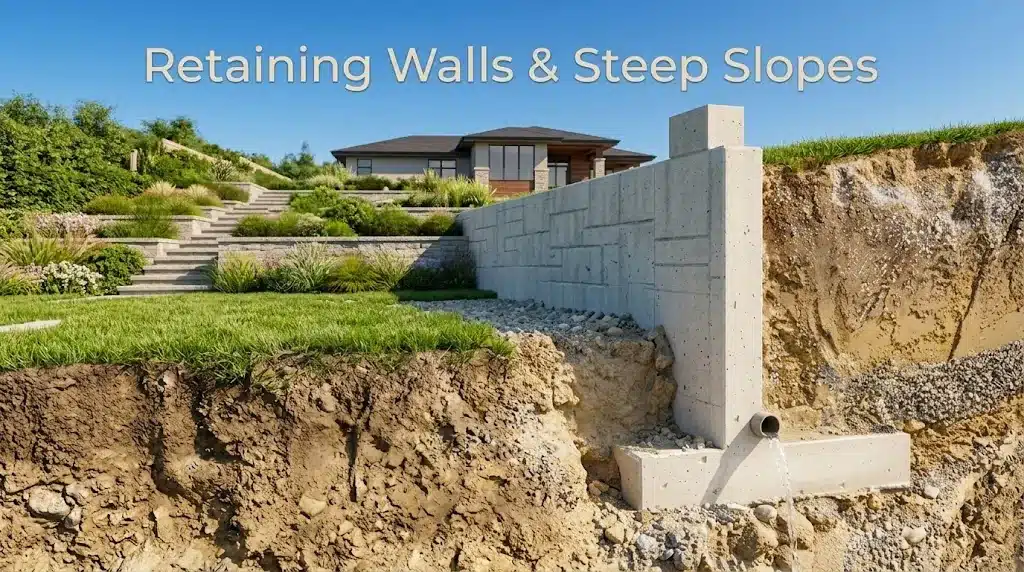
Before you begin
However, building on uneven terrain comes with a distinct set of structural and legal challenges. Many homeowners approach property upgrades on sloped land the same way they would on a flat suburban lot. They select a beautiful structure, hire a contractor, and expect a quick, routine approval from their local building department. It is only when the permit application is red-flagged or rejected entirely that they realize the hard truth: municipalities view steep slopes and retaining walls with an incredible level of scrutiny. Unlike a standard storage shed built on flat ground or a simple low-profile deck, modifying a slope or erecting a retaining wall fundamentally alters the geology, hydrology, and safety profile of your land. When you move earth, you change how gravity and water interact with your property—and your neighbors’ properties. One wrong calculation can lead to structural failures, soil erosion, mudslides, or severe downstream drainage issues.
A retaining wall site plan brings the wall location, slope conditions, setbacks, drainage, and nearby structures into one drawing for municipal review.
To prevent these disasters, building departments enforce strict zoning ordinances, grading regulations, and engineering standards specifically tailored to hillsides. Navigating these rules requires highly accurate, professional documentation.
At Prime Site Plan, we specialize in preparing permit-ready site plans that accurately reflect the complex realities of sloped terrain. By cross-referencing localized topographic data with official GIS land records, we ensure your submittal contains the precise dimensions and spatial context that municipal reviewers demand.
A complete retaining wall site plan helps reviewers understand the proposed work before excavation changes the existing terrain.
In this guide
Jump directly to the section you need.
Retaining Wall Site Plan: What You'll Learn
In this comprehensive guide, we will unpack everything you need to know to successfully permit a retaining wall or execute a project on a steep slope. By the end of this article, you will understand:
This retaining wall site plan guide explains the permit, zoning, drainage, and documentation issues that most often affect hillside projects.
- The Core Science: Why sloped properties trigger intensive municipal reviews and engineering mandates.
- The “Magic Threshold”: When a retaining wall requires a structural permit versus when it can be built without one.
- Zoning & Setbacks: How slope-specific setbacks, property lines, and easements dictate where you can safely build.
- Hydrology & Grading: Why stormwater management and drainage plans are the lifeblood of hillside approval.
- Choosing Your Documentation: When a Standard Site Plan is sufficient and when a highly detailed Elite Site Plan featuring custom topography is mandatory.
- Common Pitfalls: How to avoid the critical layout errors that stall municipal approvals for months.
Whether you are looking to stabilize a failing slope, build an Accessory Dwelling Unit on a hillside, or terrace your yard for a stunning outdoor living space, this guide will save you thousands of dollars in avoidable design errors and structural compliance penalties.
Why a Retaining Wall Site Plan Matters on Sloped Properties
To understand why building departments are so strict about slopes, you have to look at the property through the lens of civil and structural engineering. In its natural state, a hillside achieves a delicate equilibrium known as the angle of repose—the steepest angle at which soil remains stable without slipping.
The moment you clear vegetation, excavate the toe of a slope, or add the weight of a new structure to the top of a hill, you disrupt this natural equilibrium.
When a slope fails, the consequences are catastrophic. A collapsed retaining wall or a localized landslide doesn’t just damage your yard; it can undermine the foundation of your primary residence, crush a neighbor’s property, or sever municipal utility lines.
Because of these extreme liabilities, plan reviewers look at hillside development as a high-risk scenario. When evaluating an application for a steep slope project, reviewers must verify global stability, surcharge loading, and erosion control.
A retaining wall site plan should reflect these slope risks instead of treating the wall as an isolated backyard feature. The U.S. Geological Survey overview of slope movement explains why geologic conditions and development must be evaluated together.
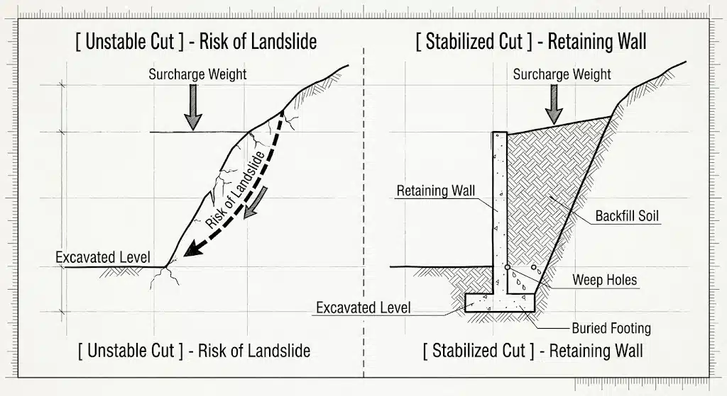
Figure 1: A technical cross-section comparing an unstable open excavation prone to landslides versus a properly stabilized hillside cut utilizing a retaining wall with gravel backfill and drainage weep holes.
Retaining Wall Site Plan Permit Threshold: When Do You Need a Permit?
One of the most frequent questions we receive at Prime Site Plan is: “Do I really need a permit for a backyard retaining wall?”
The answer depends almost entirely on the height of the wall and the local building codes governing your municipality. While every town has the legal authority to set its own rules, the vast majority of jurisdictions in the United States follow the guidelines established by the International Building Code (IBC) and the International Residential Code (IRC).
The retaining wall site plan is often the primary layout document used to compare wall height, location, setbacks, and surcharge conditions.
The 4-Foot Rule Explained
The 2024 International Residential Code permit exemptions list retaining walls not over 4 feet in height, measured from the bottom of the footing to the top of the wall, unless the wall supports a surcharge. Local amendments can be stricter, so the authority having jurisdiction should always be checked.
A retaining wall site plan should document this measurement and any surcharge condition clearly.
Important permit note
CRITICAL NOTE: Many homeowners mistakenly measure only the visible portion of the wall above the ground. If your wall shows 3.5 feet of block above the dirt, but relies on a 1-foot deeply buried gravel and concrete footing to stay upright, your total structural height is 4.5 feet. This means you legally require a permit.
Your retaining wall site plan should show total structural height, including the buried footing, rather than only the visible wall.
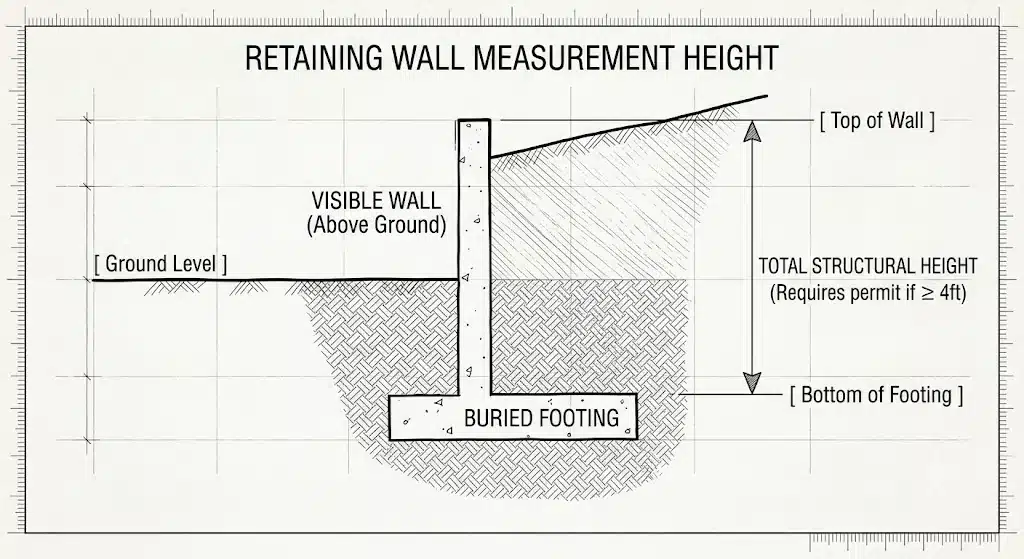
Figure 2: Engineering layout demonstrating the correct way to measure total structural height, emphasizing that the calculation must include both the visible wall above ground and the completely buried footing.
Factors That Lower the Permit Threshold
Even if your planned wall is under 4 feet tall, you may still need a structural permit and engineering stamps if any of the following conditions apply:
A retaining wall site plan must also identify surcharge loads, sloping backfill, tiered walls, and other conditions that can trigger additional review.
- Surcharge Loads: If there is a driveway, a parking pad, a patio, a swimming pool, or an accessory structure located within a distance equal to the height of the wall from the top of the structure, it is considered a “surcharge.” This extra weight exerts immense lateral pressure on the wall, triggering an automatic permit review.
- Tiered Wall Systems: Building two 3-foot walls close together to avoid the 4-foot permit rule is a common DIY tactic. However, municipalities catch this immediately. If the upper wall sits within the failure wedge of the lower wall, their weights combine, and they are treated as a single, massive structural wall system that requires professional engineering.
- Supporting Slopes: If the ground above the retaining wall slopes upward rather than laying flat, the continuous weight of that hillside pushes hard against the structure. This requires specialized calculations regardless of total wall height.
If you are combining a retaining wall with other backyard improvements like a new terrace or entertainment area, our Deck & Patio Zoning Guide provides deeper insights into how multiple structural elements interact under municipal scrutiny.
Retaining Wall Site Plan Setbacks on Sloped Lots
When building on flat ground, measuring a setback is incredibly straightforward: you pull a tape measure from the property line to the wall of the house. On a steep slope, setbacks become geometrically complex and strictly regulated.
On sloped property, a retaining wall site plan should document both property-line setbacks and the wall’s relationship to the top and toe of the slope.
Slope-Specific Setback Rules
Many municipalities enforce unique “slope setbacks” designed to protect structures built near the top or bottom of a hill. These are often referred to as Toe-of-Slope and Top-of-Slope setbacks.
The retaining wall site plan gives the reviewer a scaled way to verify those slope-specific clearances.
- Top-of-Slope Setback: Structures built at the crest of a hill must be set back far enough from the edge to ensure that if the face of the slope erodes or shears away, the foundation of the building remains completely secure on stable bedrock.
- Toe-of-Slope Setback: Structures built at the base of a hill must maintain an adequate distance from the slope to prevent natural rockfalls, soil creeping, or structural wall blowouts from crushing the living space.
If your retaining wall or terraced project sits too close to an official property boundary, it can quickly be rejected during the zoning phase. Furthermore, you must ensure your grading cuts do not accidentally encroach upon neighbor lines or recorded city easements.
To see an isometric layout of how municipal reviewers evaluate structure placements, setbacks, and secondary buildings near slopes, refer to our comprehensive ADU Development & Playground Topography Plans Guide.
Retaining Wall Site Plan Drainage and Hydrology
Ask any civil engineer why retaining walls fail, and they will give you a single-word answer: Water.
Soil expands and grows incredibly heavy when saturated with rainwater. If a retaining wall acts like a dam, blocking that water from moving downhill, the water builds up an immense force known as hydrostatic pressure. This pressure is the number one cause of wall blowouts, cracking, and structural tilting.
Because of this, municipal reviewers will never approve a major retaining wall or steep slope site plan unless it clearly details how water will be managed, diverted, and safely discharged.
For that reason, a retaining wall site plan should clearly show drainage paths, outlets, swales, and other measures used to control water.
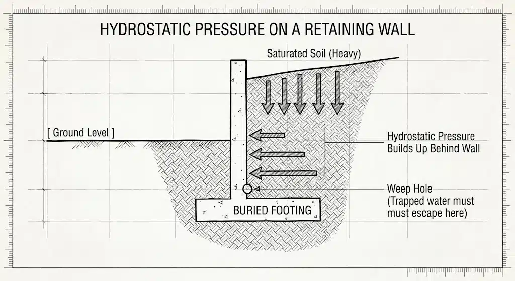
Figure 3: Engineering diagram illustrating how hydrostatic pressure builds up behind a wall from saturated heavy soil, and how functional weep holes allow trapped water to escape.
Essential Drainage Elements for Your Site Plan
A retaining wall site plan for sloped terrain must clearly show how the proposed layout accounts for hydrological changes. Key features include:
- Behind-Wall Drainage Systems: Indicating the placement of perforated drainage pipes (French drains) and clean crushed gravel backfill behind the wall to collect subsurface water.
- Weep Holes: Showcasing specific exit points along the face of the wall where trapped water can safely bleed out before building up pressure.
- Swales and Diversion Ditches: Illustrating shallow, sloped channels lined with grass or stone that catch surface water runoff uphill and guide it around your new structures rather than allowing it to cascade directly over the wall.
- Impervious Surface Calculations: When you install concrete blocks, stone terraces, or paved steps on a slope, you reduce the ground’s natural ability to absorb water. Reviewers calculate these metrics carefully to prevent flooding.
If your sloped project is part of a larger landscaping overhaul that includes a pool, managing water becomes twice as important. Check out our Pool Permit Site Plan Guide to learn how pools and extensive hardscaping interact with municipal stormwater and lot coverage regulations.
Retaining Wall Site Plan vs. DIY Drawings
With the rise of satellite mapping software and accessible design tools, it can be tempting for a homeowner to try and draft their own steep slope site plans. While a hand sketch or a Google Earth printout might look clear enough to show a contractor where you want a wall, it is almost completely useless to a city plan reviewer.
Municipalities require precise, geometrically accurate documentation. A freehand drawing simply cannot convey the technical data points that prove your hillside project is safe.
A professional retaining wall site plan replaces visual guesswork with dimensions and property information that can be checked during permit review.
The Danger of Relying on Basic Satellite Images
Satellite screenshots provide an optical overhead perspective, but they suffer from severe spatial distortions. Tree canopies block out the ground, structural roof overhangs mask true foundation lines, and slopes look completely flat from a bird’s-eye view.
If you submit a site plan that miscalculates your wall location by even twelve inches, you risk breaking setback laws, cutting into utility lines, or receiving a formal “Stop Work” order after thousands of dollars have already been poured into concrete.
To truly understand how spatial analysts verify property boundaries and structural positioning using advanced data streams, explore our specialized guide on GIS Land Records & Professional Site Verification.
A retaining wall site plan based only on an aerial image can miss elevation changes, easements, and the true location of foundations.
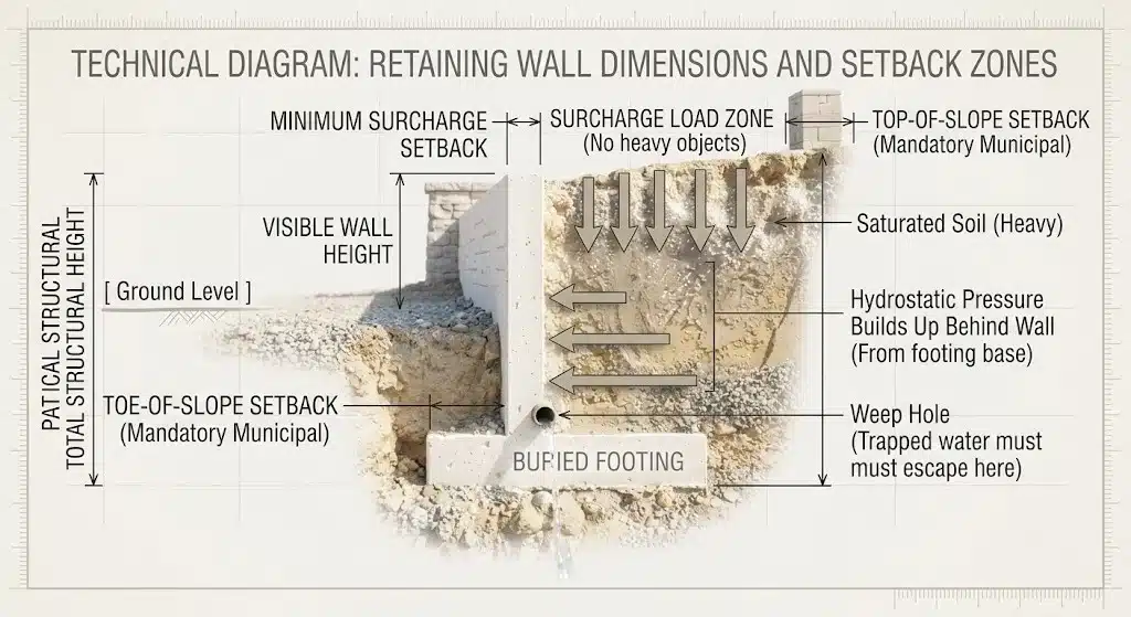
Figure 4: A comprehensive, realistic 3D architectural cross-section overlaying municipal setback definitions, surcharge load zones, and engineering parameters onto a clean, bright background.
Choosing the Right Retaining Wall Site Plan
Every property is unique, and not every slope project demands the exact same volume of structural detailing. At Prime Site Plan, we offer tailored packages designed to meet the specific requirements of your project while keeping your permitting costs efficient.
When a Standard Site Plan is Perfect
For straightforward residential upgrades on properties with mild, predictable inclines, our Standard Site Plan provides exactly what your local building department needs. This package includes verified property lines, exact dimensions of existing structures, the clear layout of your proposed retaining wall or terrace, and detailed setback metrics.
If your wall is under the 4-foot structural engineering threshold and your yard has a gentle slope, the Standard Site Plan delivers an organized, permit-ready submittal that bypasses unnecessary delays.
For a mild slope and a straightforward wall, this retaining wall site plan option can provide the core information needed for review.
When Your Property Demands an Elite Site Plan
If you are dealing with a truly challenging piece of land, a Standard Plan will not be enough. You will need the advanced structural clarity of our Elite Site Plan.
You should opt for the Elite Site Plan package if your project involves:
Complex terrain usually requires a retaining wall site plan with topographic contours, grading context, and more detailed slope documentation.
- Steep Hillside Parcels: Properties with a grade incline exceeding 10–15%.
- Significant Topographic Contours: Environments where the exact elevation changes of the ground must be mapped out across every few feet of land to prove drainage compliance.
- Tiered Wall Designs: Complex structural layouts where multiple retaining walls support one another across a slope.
- Large Backyard Developments: Multi-tier projects combining an ADU, a patio, a slope cut, and extensive structural footings simultaneously.
Our Elite Site Plan introduces custom topographic contours, advanced grading visualization, and deep spatial analytics tailored specifically for demanding hillside reviews.
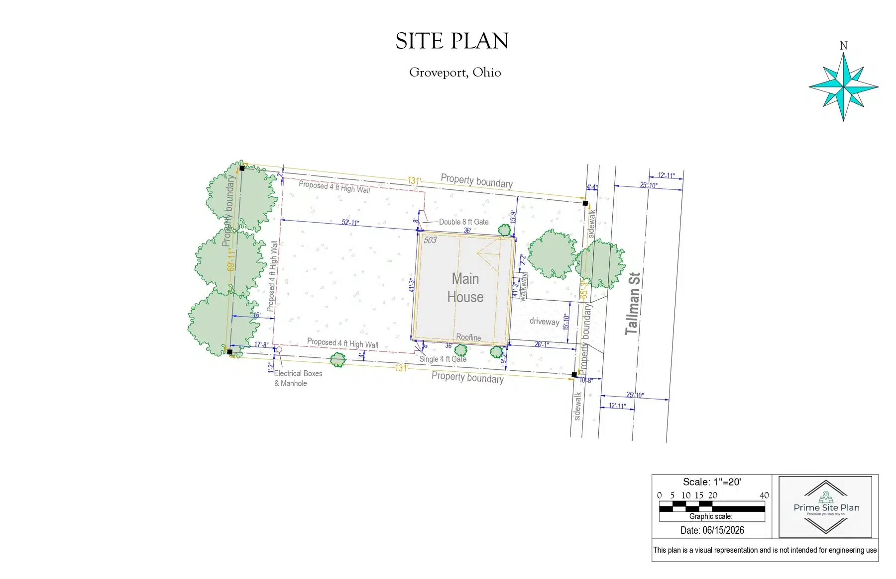
Figure 5: A real-world example of a completed, permit-ready residential site plan showcasing exact property boundaries, clear building setbacks, and approved retaining wall layouts ready for municipal submittal.
5 Retaining Wall Site Plan Mistakes That Delay Approval
To keep your project moving forward smoothly, avoid these five common mistakes that regularly cause homeowners to get stuck in municipal zoning loops:
Each retaining wall site plan mistake below can create another municipal review cycle or force the proposed layout to be revised.
1. Failing to Check for Hidden Easements
A retaining wall is a permanent concrete or masonry structure. You cannot build it over a city utility easement. If a subterranean sewer, water main, or electric line runs through your slope, the city will reject your plan instantly. Always cross-reference your layout with verified county land records before finalizing your wall location.
A retaining wall site plan should identify recorded easements before the wall alignment and footing are finalized.
2. Forgetting About Construction Access
A retaining wall requires heavy equipment—excavators, bobcats, and concrete trucks. A common mistake is planning a beautiful hillside terrace that physically cuts off access to the rest of your yard, or failing to show the city how machinery will safely access the slope without damaging neighboring properties.
3. Ignoring the "Surcharge Failure Wedge"
If you plan to place a heavy feature—like a parking space, a playground, or a storage shed—near the top of your wall, you must plan for it from day one. Failing to indicate a surcharge load on your initial site plan submittal can lead to wall failure later, or structural code violation fines from an inspector.
4. Designing Walls Independently of Stormwater Outlets
Never design a wall without showing exactly where the collected water goes. If your pipe drains directly onto a neighbor’s property or over a public sidewalk, your permit will be denied. Your plan must show water routing into approved drainage ditches, dry wells, or municipal storm systems.
The retaining wall site plan should show where collected water is discharged so reviewers can confirm that runoff will not be redirected onto neighboring property.
5. Overlooking Global Slope Stability Rules
Cutting deep into the base of a hill to create a flat pad might look fine locally, but it can destabilize the upper half of the mountain. Always ensure your site documentation treats the entire hillside as a connected ecosystem rather than looking at the wall in complete isolation.
Do I need a retaining wall site plan to replace an existing wall?
Yes. In almost all jurisdictions, replacing a structural wall is treated the same as building a new one because the earth must be re-excavated and a new structural footing must be engineered to meet modern building codes.
Can a retaining wall cross over an official property line?
Absolutely not. A retaining wall, including its underground structural footing and drainage gravel, must sit entirely within the legal boundaries of your property, unless you have a formal, notarized easement agreement signed by your neighbor and recorded with the county.
How do I know the exact slope or incline percentage of my yard?
You can find rough slope data via regional GIS databases, but for an official permit application, using a professional mapping service like Prime Site Plan ensures that elevation changes are accurately calculated and translated onto your document using official, scaled topographic contour metrics.
An accurate retaining wall site plan converts elevation and parcel data into dimensions that contractors and reviewers can use.
What happens if I build a retaining wall over 4 feet without a permit?
If code enforcement discovers an unpermitted wall, they can issue heavy fines, place a formal title hold on your home, or legally force you to tear down the wall entirely at your own expense—even if the construction is structurally sound.
Is an engineering stamp required for every Elite Site Plan?
Our Elite Site Plan provides the highly accurate spatial layouts, topographic contours, and dimension tracking that cities require for their reviews. If your local building code mandates a structural engineering stamp due to an extreme wall height or surcharge load, our clean plans provide the perfect foundation for an engineer to review and sign off on quickly, saving you expensive hourly drafting fees.
Final Retaining Wall Site Plan Checklist
Modifying a steep slope or constructing a heavy retaining wall is a powerful way to reclaim your land, prevent destructive erosion, and dramatically boost your home’s curb appeal. But because hillsides present real geological risks, a successful project always hinges on precise planning and flawless municipal documentation.
Do not let inaccurate drawings, guessed property boundaries, or overlooked setback rules delay your project and drain your construction budget. By submitting a clean, professionally drafted site plan from day one, you give city reviewers the exact answers they look for, paving the way for a fast, hassle-free approval process.
At Prime Site Plan, we take the guesswork out of property development by transforming complex GIS land records and topographic data into clean, permit-ready documents.
Ready to unlock the true potential of your sloped property? Choose the professional site plan package that fits your layout goals today:
A well-prepared retaining wall site plan gives reviewers a clear basis for checking the wall before construction begins.
- Standard Site Plan — Optimized for straightforward retaining walls under 4 feet, simple terracing, and mild backyard slope adjustments.
[Get Your Standard Site Plan Package]
- Elite Site Plan — Engineered for complex hillside properties, steep terrains, tiered walls, heavy surcharge load structures, and projects requiring advanced topographic elevation contour detail.
[Get Your Elite Site Plan Package]
Choose the right site plan for your project
Both options are professionally drafted to support a clearer municipal review for slopes & retaining walls projects.
Standard Site Plan
Suitable for simpler retaining-wall layouts on mild slopes when the municipality does not require advanced topography.
Elite Site Plan
Recommended for steep grades, tiered walls, significant elevation changes, drainage analysis, and complex hillside development.